- HubPages»
- Travel and Places»
- Visiting North America»
- United States
Road Trip to Sedona Arizona - A Photo Essay

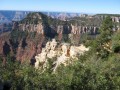
Sedona is a beautiful city in the north central part of Arizona. Its main attraction is the red sandstone hills amongst which it nestles. It is not a big city but has achieved a reputation as a major tourist area as well as being both an artist colony and magnet for New Age types interested in contact with other worlds. There are supposedly portals in the vacinity where one can be teleported out or something like that.
My wife and I purchased a small interest in a time share in Sedona about a year ago and had recently received an invitation to drive up for an update on the company's latest additions to their chain of resorts (with which we have exchange privliges). They offered us $300 to come and hear a sales presentation and, of course I accepted.
So, on a cold, January morning (in Tucson, any time the temperature drops below 60 to 65 F it is considered unbearably cold - this particular morning it was in the low 40s) we got on Interstate 10 and headed north.
Since we live north of downtown, traffic on the interstate was going in the opposite direction toward the center of the city while we had clear sailing going away from the city center. Soon we were across the county line and Picacho Peak came into view on our left.

Rooster Cogburn Ostrich Ranch

Passing Picacho Peak
One of the many buttes in the state, Picacho Peak sits in the middle of a state park of the same name and is the site of the only battle fought between Union troops and Confederate troops in Arizona during the Civil War. Arizona was just a territory, not a state, at the time of the war and was nominally associated with the Confederate States of America during the war but didn't pay much attention to the war.
Just outside the park and bordering the western edge of the interstate is Rooster Cogburn's Ostrich Ranch, one of the survivors of the ostrich and emu farming craze a decade or so ago. With their high ratio of meat per pound of bird, the health benefits of ostrich (and their New Zealand cousins the emu) meat and the medical uses for their oil, many people started ostrich and emu farms at that time. Like booms in other products, the high prices attracted many suppliers and soon the market had all the ostrich products it needed and the weaker ventures failed leaving stronger ones like Rooster Cogburn's as the survivors. I think that it was this ostrich ranch also played a cameo role a few years ago in the then controversial (at least with the Post Office) video game Postal which was created by the Tucson based software game firm Running With Scissors.
Picacho Peak

Rest Stop on Interstate 10

Gadsden Purchase

Indians Selling Native Jewelry at Rest Stop

Gila Indian Reservation


The $10,000,000 Land Purchase
Continuing north, we made our first stop of the day at the highway Rest Area just south of Phoenix. This Rest Area sits on the northern boundary of what is known as the Gadsden Purchase.
Following the Mexican War (1846-1848) the Treaty of Guadalupe Hidalgo confirmed the U.S. claim on the state of Texas (which had gained its independence in 1836 and had been admitted to the Union as a State in 1845) as well as ceding to the U.S. what are now the states of California, Nevada and Utah as well as parts of Arizona, New Mexico, Colorado and Wyoming totaling about two-fifths of the original land area of Mexico.
The area ceded to the U.S. in this treaty didn't include the southern third of present day Arizona or the lower part of New Mexico. However, a number of Southern business interests, including James Gadsden, the President of the South Carolina Railroad Company, wanted to tie the economies of the newly acquired territories to the South by running a railroad from the South to California and thereby giving the South more clout in Congress.
However, due to geography, the best route lay to the south of the new U.S. - Mexican border. Gadsden's friend, the then Secretary of State, Jefferson Davis, in the Cabinet of President Franklin Pierce, arranged for Gadsden to be appointed as Ambassador to Mexico where Gadsden promptly started negotiating to purchase the desired land for the U.S.
In 1852 Gadsden succeeded in getting the Mexican President Antonio Lopez de Santa Anna to sell the desired territory, consisting of 29,640 square miles in what is now southern New Mexico and southern Arizona for $10,000,000 in gold. A good deal that worked out to about 33 cents an acre but nowhere near as good as the earlier Louisiana Purchase from France which came to about 3 cents an acre or later Alaska Purchase from Russia which came to about 2 cents an acre.
As a result of the Gadsden Purchase our stop at this point was merely a rest stop for pictures rather than a mandatory border crossing stop.
Leaving the rest area we resumed our trip north on I-10 and soon passed the exit for the Gila Indian Reservation with its museum and culture center. Having a number of miles to go and a 3:00 p.m. appointment in Sedona, we continued on without stopping.
Besides, I had visited this a number of years ago with my sons. This reservation was the birthplace of Ira Hayes, one of the Marines in the Joe Rosenthal's Pulitzer Prize winning photograph of the Marines raising the American flag atop Mt. Suribachi on Iwo Jima during World War II. The cultural center has an exhibit area dedicated to Ira Hayes and the raising of the flag.
In addition to the Cultural Center there is another, more shameful, reminder of World War II to be found at this exit. A new sign attached to the exit sign announces that the exit will also take one to the remains of the old Gila River Internment Camp where Americans of Japanese descent were interned during World War II under the terms of Executive Order Number 9066 issued on February 19, 1942 by President Franklin D. Roosevelt.
Approximately 120,000 people of Japanese ancestry (over 60% of whom were born in the U.S.) were interned in camps which were located in remote areas of the west, usually on Indian Reservations like the Gila River Reservation (for which the reservations did not receive any compensation from the Federal Government).


There were two internment camps in Arizona, the one at Gila River and one further northwest in Poston. During the war the population interned in the Poston camp made it the third largest city in Arizona after Phoenix (largest) and Tucson (second largest) with Gila River right behind as the fourth largest city in the state for that period.
Ironically, while the government felt it necessary for national security to confine citizens of Japanese ancestry in camps surrounded by armed guards, they had no qualms about drafting young men from the camps as they came of age and sending them to fight in both the European and Pacific theaters of the war.
In 1988 President Ronald Reagan issued an apology to those who had been interned and signed legislation providing monetary compensation to the victims of the wartime internment policy. In December of 2006 President George W. Bush signed legislation providing funds to the National Park Service to preserve the camps as a remembrance of that era.
At 85 miles per hour, there wasn't time to get my camera out and take a picture and, so as not to lose any more interesting shots, I gave the camera to my wife along with a quick lesson in its use. She then took the remaining pictures from the road for me.

Sign Announcing Big Bug Creek


San Fransisco Peaks in Distance

Snow Covered San Fransisco Peaks

Entering Verde Valley

Wide Open Country North of Phoenix
Having left Tucson shortly after 8 a.m., we hit Phoenix shortly after the worst of the morning rush hour and were able to sail through at 60 - 65 mph with the rest of the traffic.
While the city continues to grow in all directions it begins to thin out as one reaches the northern limits of Maricopa County and the countryside opens allowing one unlimited view from horizon to horizon.
This vast open area is dotted here and there with tiny hamlets and ghost towns. Some day I plan to pull of and explore each of these exits, but for now I have to satisfy myself with photos (taken courtesy of my wife) of exit signs and Internet links to their stories.
Bloody Basin is located just north of Cave Creek, a town and regional park which takes its name from a creek of the same name which starts in a cavern at the top of a nearby mountain and flows down into Paradise Valley below.
In the 1870s this area was a stomping ground for both the Tonto Apache tribe and settlers who were mostly gold miners. Of course there was conflict and the army was called upon for help.
At dawn on March 27, 1872 a group of Army scouts (who were usually Indians from other tribes who worked for the Army as scouts) surprised a group of Apaches on Turret Peak.
The scouts had been trailing the Apaches and during the night had crept up on the Apache camp. Attacking at dawn, the scouts killed or captured all but a few of the Apaches in the group and since then, this area has been known as Bloody Basin.
Further up the road we cross Big Bug Creek which was quickly named by a group of miners in 1863 who were attacked by numerous large flying bugs as they made their way up the canyon searching for gold.
In their misery, these fellows, who were obviously seeking quick profits from the discovery of gold, did not take time to consider the effect of the name on future real estate sales. But then, neither did those who attached the name Bloody Basin to the lands south of the creek.
Continuing on we come to the exit for Bumble Bee. My wife was taking a nap and we didn't get a picture of this or the sign for Horse Thief Basin Recreation area. While the names are colorful and obviously, especially at the time of naming, descriptive those who named these areas obviously were not concerned about the names' effect on future real estate sales.
In the case of Horse Thief Basin real estate sales are not a problem as it lies within the Prescott National Forest and is off limits to private development.
You know that there is not much to Bumble Bee because the sign clearly states that there are no services at this exit. Actually, Bumble Bee is a ghost town, the remains of an old mining town whose original settlers were attacked by, you guessed it, a swarm of Bumble Bees!
Likewise, Horse Thief Basin was, in the 1860s, home to bands of thieves who stole horses (a serious crime given that a man's livelihood, and often his life, in this area depended upon his horse) and other livestock.
We now begin the climb to the high country overlooking the Verde Valley. Trucks have to stay in the right lane because of their slow progress up the steep incline while many of us manage to pass them.
Eventually we reach the top and get a spectacular view of the lands below. This day is so clear that we are able to see the mighty snow capped San Francisco Peaks, the highest points in Arizona, which are located a considerable distance away to the north of Flagstaff.
Unlike other mountain peaks in Arizona, these peaks tower above the tree line and are snow capped year round (snow falls on the other mountain peaks but, being below the tree line, viewers from below can only view it for a few hours while it is on the trees - once it falls from the tree tops it is no longer visible from the lands below the peak).
We pass signs marking exits for the Tuzigoot National Monument and Montezuma Castle National Monument both constructed in pre-Columbian times.
When first discovered, the Montezuma Castle site was thought to have been built by the Aztecs and was named accordingly. However, later research revealed that it was constructed and used by a people known as the Sinagua Indian peoples who resided there between about 1100 and 1400.
Exit for Bloody Basin


Exit for Sedona

Sedona and Village of Oak Creek
A little before noon we reached the turn off for Sedona.
A couple of minutes later we found ourselves entering the scenic Red Rock Country as we entered the Village of Oak Creek located on the south side of Sedona.
Ahead of us as we entered the village was a bell shaped butte aptly named Bell Rock. According to one of the locals, as the millennium approached, an enterprising individual, taking advantage of the New Age lore surrounding the Sedona area, sold tickets to view Bell Rock launch itself into space at midnight on December 31, 1999 as the new minimum dawned.
Even though the butte stayed put, this enterprising con artist would have succeeded with his little scam if an enterprising lawyer hadn't sued and pointed out that, by not including a line on the tickets stating that the money was not refundable if the rock failed to take off, the scam artist was legally obligated to return all of the money.
Montezuma Castle

Entering Sedona Area

Village of Oak Creek

Bell Rock Sedona


Additional Links of Interest
- Sedona Arizona: Vortexes
- Italian American internment - Wikipedia, the free encyclopedia
- WWII Japanese Internment 2
Visions of the world and Japanese American internment in Owens Valley - Muller, Free to Die for their Country, excerpt
An excerpt from Free to Die for their Country. Also available on website: online catalogs, secure online ordering, excerpts from new books. Sign up for email notification of new releases in your field. - The Katharine Lee Bates
- America The Beautiful!
Words to the hymn "America the Beautiful" along with information about the author, Katherine Lee Bates and a picture of her home in Falmouth, Massachusetts.
Red Sandstone Butes in Sedona

 into a 2-bedroom, 1-bedroom or studio unit. We own one week's worth of stu")

Chapel of The Holy Cross

Twilight in Sedona

Related

How Sedona Arizona Got Its Name: Sedona Schnebly 1877- 1950

A Drive From Mesa to Sedona Arizona, With a Photo Album

Arizona Vacation Ideas: Amazing Attractions and Scenery

Visiting the Fabulous Oak Creek Canyon, Slide Rock State Park and Sedona, Arizona

Attractions for Families in the City of Surprise, Arizona